|
|
|
|
Hurricane season starts in two weeks, and forecasters are eyeing the Gulf of Mexico with increasing concern. A powerful current of warm, tropical water known as the Loop Current is reaching farther into the Gulf than normal. Its heat can cause tropical storms to quickly intensify into monster hurricanes, and that can spell disaster for the northern Gulf Coast.
Last year, Hurricane Ida spun up from Category 1 to 4 in less than a day after crossing a warm eddy from the Loop Current last. University of Miami marine scientist Nick Shay writes that this year, the Loop Current looks a lot like it did in 2005 – the year Hurricanes Katrina, Rita and Wilma blew up into some of the most intense Atlantic storms on record.
It’s a dangerous sign, especially with La Niña setting the stage for a busy hurricane season, Shay writes.
Also today:
|

|
Stacy Morford
Environment + Climate Editor
|
|
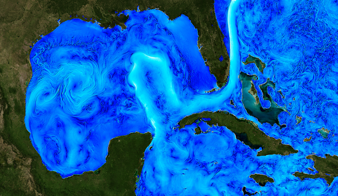
A satellite image of ocean heat shows the strong Loop Current and swirling eddies.
Christopher Henze, NASA/Ames
Nick Shay, University of Miami
With La Niña helping clear the way for a busy hurricane season, this wide current of warm water could spell disaster for the northern Gulf Coast.
|
Education
|
-
Kenneth Anthony, Mississippi State University
From the founding of the U.S., public schools were seen as a key way to develop an informed, active citizenry. Social studies educators struggle to achieve that goal today.
|
|
Health + Medicine
|
-
David Mendez, University of Michigan Medical School; Rafael Meza, University of Michigan School of Public Health
As the comment period begins for the FDA’s proposed ban, public health experts explain the stakes.
|
|
Science + Technology
|
-
Andy Weiss, Vanderbilt University; Caitlin Murdoch, Vanderbilt University
While iron and calcium are the metals that get the most attention, zinc is also important for human health and function.
-
Tam Nguyen, University of Dayton
Developing software used to require programming skills. Today, a growing number of people are building websites, games and even AI programs without writing a line of code.
|
|
Arts + Culture
|
-
Paul Morrow, University of Dayton
Their drawings and paintings often express a mix of horror, fear, hope and beauty.
|
|
Politics + Society
|
-
Ronald Suny, University of Michigan
Turkish president Recep Tayyip Erdogan is against allowing two Scandinavian countries to join NATO over what he deems their support of ‘terrorists.’ His opposition will test the alliance’s unity.
-
Eve Ringsmuth, Oklahoma State University
A Supreme Court scholar explains the significance of the recent Supreme Court leaked draft opinion.
-
Astraea Augsberger, Boston University; Mary Elizabeth Collins, Boston University
Despite a series of federal measures requiring greater efforts to preserve family unity, many policies make life harder for people swept up in the system.
-
Ronald Hall, Michigan State University
A scholar of social work shares what he has learned about colorism by conducting research in more than 20 countries over the past few decades.
-
Monika L. McDermott, Fordham University; David R. Jones, Baruch College, CUNY
Your willingness to get a vaccination is tied to your political party. And that may have deadly consequences.
|
|
|
|
Today's graphic |
|---|
| | More from The Conversation US |
|---|
| |
|
| |
| |
| |
| |
|
|
|
|
|
|
|